Bike required
These rides are wholly or mainly on unmade roads or marked tracks and are not suitable for road bikes. You will need a gravel bike, a hybrid, or a mountain bike (MTB).
Information about routes
This page has brief descriptions of the routes, and links to maps and digital (GPX format) files. Further descriptions can be obtained from the companion book: 17 Gravel Bike Rides – Maldon and Beyond. This can be obtained from the Castlemaine and Maldon Visitor Information Centres, bike shops and bookshops and some cafes in Maldon, Castlemaine, Harcourt and Bendigo.
Each route can be travelled in either direction, with a little planning.
G1. Tarrengower Circuit and G1V. Tarrengower Circuit – Longer Variant
G1 is an easier ride of 15 km that circumnavigates Mt Tarrengower and offers panoramic views to the west. The ruins of the North British Mine are passed on the return into Maldon. A PDF map, ride description and a GPX file can be downloaded.
G1V is a slightly longer version with a little more climbing. It is shown on the same PDF map as G1. A GPX file and ride description can be downloaded..
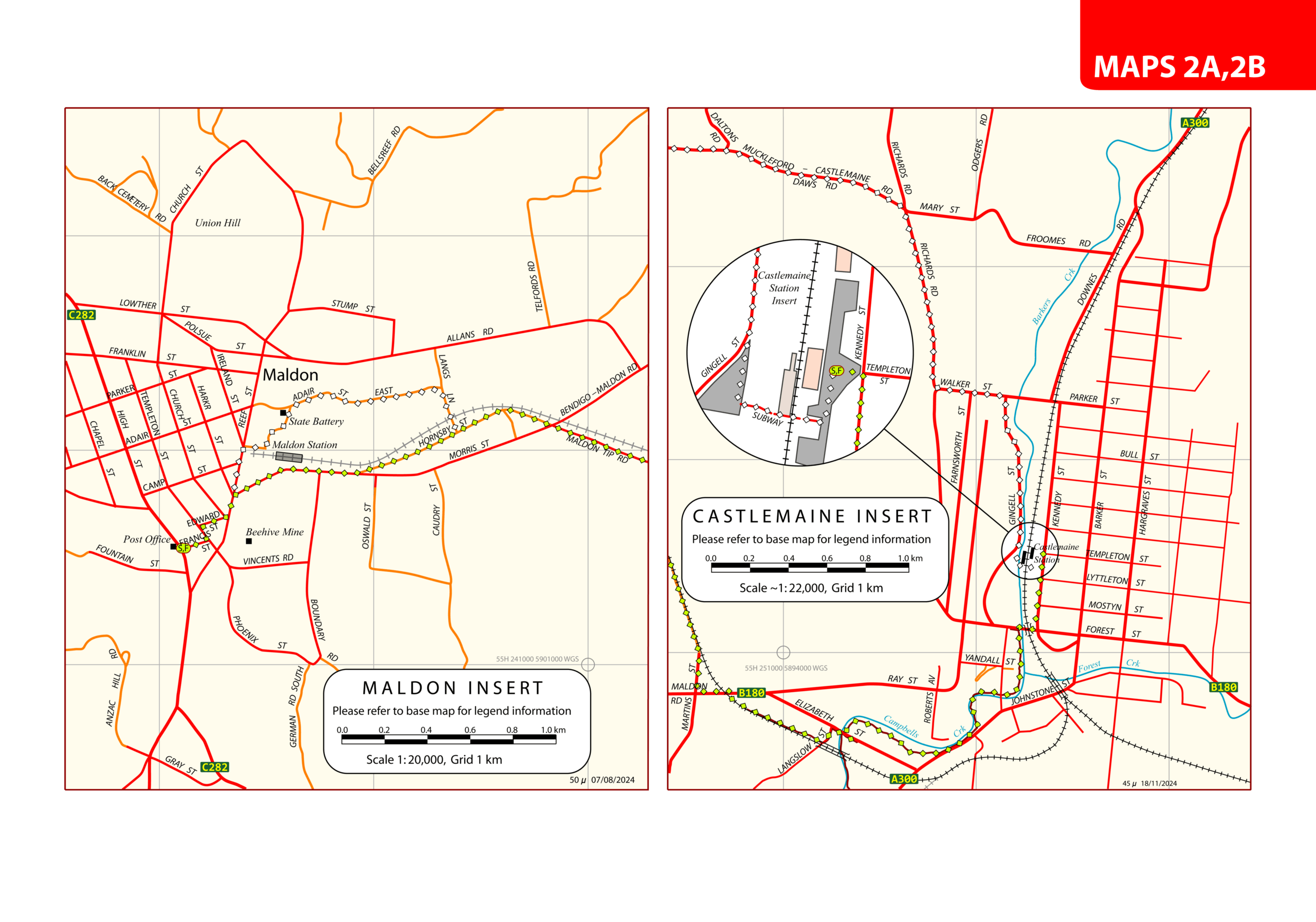
G2 and G2V. Castlemaine Maldon Trail
Route G2 generally follows the marked Castlemaine Maldon Trail, next to the railway line for most of the distance, and is sometimes incorrectly described as a ‘rail trail’. It can be ridden as a round trip. With some planning it can be ridden one-way, with the return trip by vintage VGR steam train or local bus, . Each leg is almost 20 km. A PDF map, ride description and a GPX file can be downloaded. A map showing further details of Maldon and the Castlemaine Station precinct can also be downloaded.
An alternative route – G2V from Castlemaine to Maldon is also recommended. This route follows quiet paved roads through forest and grazing country from Castlemaine to Muckleford Station, where the trail beside the railway is followed. It offers a pleasant alternative return route to Maldon and has marginally less climbing (30 m) than experienced using the entire trail next to the railway line. The G2 PDF map also shows this route and a ride description and a GPX file can be downloaded. A map with further details of Maldon and the Castlemaine Station precinct can also be downloaded.
G3. Castlemaine via Lewis Road
This is an alternate route into Castlemaine from Maldon, mainly on an interesting dirt road which carries low levels of traffic but which can be corrugated at times. The last few km are on paved roads. A PDF map, a ride description, and a GPX file can be downloaded. A map with further details of Maldon and Castlemaine Station precinct can also be downloaded.
G4. Barry’s Loop of Lanes
This is a longer (35 km) and more challenging ride from Castlemaine to Maldon mainly on quiet dirt roads with scenic views, through bush and farming land. A PDF map, a ride description, and a GPX file can be downloaded. A map with further details of Maldon and the Castlemaine Station precinct can also be downloaded.
G5. Donkey Farm Track
The ride initially follows the marked Castlemaine Maldon Trail towards Castlemaine for about six km, before entering Muckleford Forest. Although only 21 km, some moderate climbs and exhilarating descents on Donkey Farm Track make this ride slightly more challenging. The return to Maldon passes former mine workings at Smiths Reef and the Maldon State Battery.
A PDF map, which also shows G6, a ride description, and a GPX file can be downloaded.
G6. A Frame Track
This route follows the marked Castlemaine Maldon Trail to Muckleford Station. It then uses a paved road for several km before entering the Muckleford State Forest. It takes several unmade tracks . You will come to a barrier at the end of A Frame Track. This requires a slight diversion to join Cruits Lane. Continue past the Red, White & Blue Mine, back to Maldon. A PDF map, which also shows G5, a ride description, and a GPX file can be downloaded.
G7. Muckleford Station – Red, White and Blue Mine
This ride follows gravel tracks through Maldon Historic Reserve and Muckleford State Forest to the remains of the Red, White and Blue mine, which operated until 1960. The return ride, which includes a short bitumen section, passes Frenchmans Reef Tunnel and Maldon State Battery on the outskirts of Maldon. This a 32 km ride of moderate difficulty.
A PDF map, a ride description, and a GPX file can be downloaded.
G8. Maldon – Newstead and Return
This is a harder ride of 37 km, following a slightly meandering route, mostly on bush tracks, from Maldon to Newstead. It is is suitable for mountain bikes, gravel bikes or hybrids. The return climbs through Muckleford Nature Conservation Reserve and passes Red, White and Blue Mine.
A PDF map (the same as for G9), a ride description, and a GPX file can be downloaded.
G9. Maldon – Newstead, Return via Mia Mia Rd
This is a harder ride of 37 km, which uses the same route to Newstead, but the return includes a section along Mia Mia Rd which avoids a sharp climb from Newstead. The return ride also passes the Red, White and Blue Mine and the Smiths Reef workings in the Maldon Historic Reserve.
A PDF map (the same as for G8), a ride description, and a GPX file can be downloaded.
G10. Rock of Ages
A short (10 km) but hilly ride to two scenic lookout points on the Nuggetty Range close to Maldon.
A PDF map (which also shows G11), a ride description, and a GPX file can be downloaded.
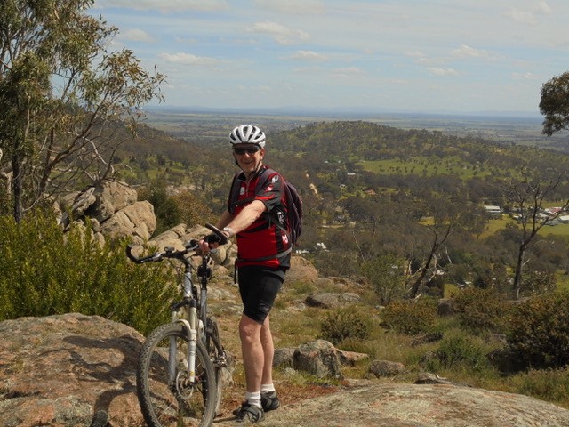
View from Rock of Ages
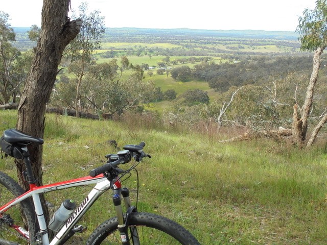
North from Darky’s Hut
G11. Nuggetty School Ride
An interesting ride to the north of Maldon through bush and farming land. Mainly on gravel roads with low traffic volumes.
A PDF map (which also shows G10), a ride description, and a GPX file can be downloaded.
G12. Tunnel Track and Smiths Reef
A pleasant ride, mostly on gravel tracks, through Muckleford State Forest passing an old mining tunnel (Frenchmans Reef Tunnel), and the Maldon State Battery.
There is a PDF map, a ride description, and a GPX file which can be downloaded.
G13. Westons Track and Tunnel Track
A slightly longer ride of 29 km on gravel tracks past the North British Mine site and then through Muckleford State Forest, passing an old mining tunnel (Frenchmans Reef Tunnel), and returning via Maldon Historic Reserve.
A PDF map, ride description and a GPX file can be downloaded.
G14 & G14V. Cairn Curran Circuit and Cairn Curran Long Variant
Route G14 is a popular circuit by Cairn Curran Reservoir through bush and farming land with scenic views. Mainly on gravel roads with low traffic volumes.
A PDF map (the same as G14V), the ride description, and a GPX file can be downloaded.
Route G14V is a slightly longer variant, via bush and farming land with some great views. This can be a very pleasant ride early in the morning or late in the afternoon. A PDF map (the same as G14), the ride description, and a GPX file can be downloaded.
NOTE: There was an error on the previous PDF map. Tarrengower School Rd was wrongly labelled as Green Hill Bridge Rd (which is a dead-end road). Please do not use Green Hill Bridge Rd.